Our Common Good

Nairn’s Common Good story is well told by ‘A Gurn from Nurn’. There you can read the full story (which was originally researched and written by Nairn West and Suburban Community Council)  but, we can take a quick look, with thanks to NWSCC, over how Nairnshire, and the town of Nairn, has been so well provided for:

  • In 1589, King James VI confirmed Burgh status on Nairn and conferred what we now call the Common Good land, then known as the Commonties, stretching from Tradespark to Kingsteps to the township;
  • the collection of tolls by the Bailies, which could be used for the benefit of the Burgh, led to the creation of the Common Good Fund, which in 1832 became a stand alone fund. The burgh and councils were free to add to the Common Good lands with further purchases, donations, and investments in land; and
  • following the 1975 local government organisation, Scottish Burghs were replaced by District and Regional Councils. District Councils were scrapped in 1995. Management and titles of Common Good assets transferred to the Regional Councils, wresting control or decision making from the community

This centralising of control was not unique to Nairn We can see this theme played out amongst all regions of Scotland.

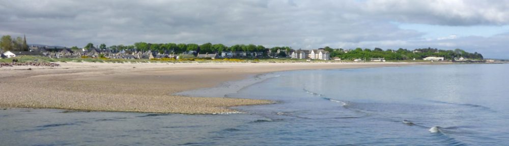
Today, NPF4 and the Planning (Scotland) Act 2019 seek to re-establish community direction in planning, giving us all the opportunity to influence the future outcomes of spatial land use in Nairnshire. What does make Nairn so unique is the successful protection of those Common Good lands. Without them, it is hard to imagine what our beach front may look like, what the riverside and river paths may have become, and what would remain of the Viewfield.

Some of those Common Good lands have been leased, such as Sandown, the caravan park, and Nairn Dunbar golf course, whilst others continue to benefit everyone with no cost, such as the Links, Riverside, and Viewfield green spaces.


We would love to know how you see those Common Good assets fitting within a future Nairn. 

How would you protect them?

How would you link them with other spaces and routes through Nairnshire?

How would you increase their value to the people of Nairnshire?

Do you think residents of the town should have more say in their management?

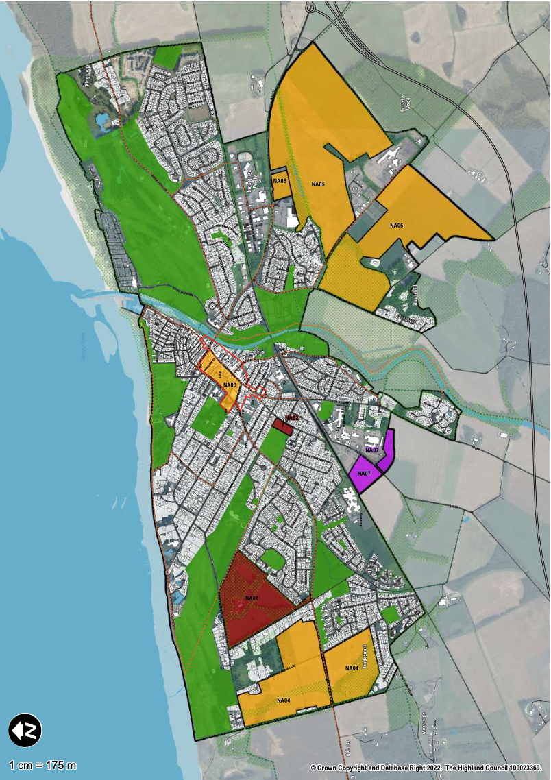
The use of spaces, such as the Common Good, and as we looked at last week, those areas zoned for development by the Inner Moray Firth Local Development Plan 2, are how our Local Place Plan can influence future spatial decision making that will shape Nairnshire for the future.

You can send us your thoughts directly at lpp@nicennairn.org.uk, or by commenting below. We look forward to hearing from you.

Nairn’s Local Place Plan Community Group consultation launches!

the Community Consultation covered Community Amenities being discussed here under the stewardship of Nairn Academy’s Deputy Head, Sarah Abenheimer

We were delighted to welcome 39 guests to our initial Community Group download session, ably hosted by Planning Aid Scotland. Participants covered a wide cross section of Nairnshire, from Nairn Access Panel leading conversation on Getting Around, to representatives from Nairnshire’s farming community. We were pleased to welcome DTAS’ Alice Duthuille, Programme Development Officer, as spectator to proceedings.

Following a brief introduction to the evening from Alastair Noble, LPP Chair, and Iain McPherson, Operations Director for Planning Aid Scotland, Iain put everyone to work in groups formed under our 5 main headings. A collaboration of organisations across Nairnshire took lead roles in the conversation, with each working group reporting back their top 3 points from the night. Participants had the chance to move amongst the groups at a half-time coffee break.

Town Centre: including heritage Conservation and Tourist Welcome

led by Nairn’s BID

  • “our beach is the town centre”
  • “regeneration will need a significant financial plan with political cooperation”
  • “regeneration of derelict/ empty buildings”

Community Amenities: Health, Education, Leisure, and Recreation

led by Nairn Academy’s Deputy Head 

  • “safe travel routes between amenities encouraging seafront sustainability with improved parking”
  • “sports facilities – can the footprint of the old Nairn Academy be reused for covered sports facilities”
  • “financing and finance”

Getting Around: sorting traffic jams, safe/ accessible paths, parking and pavements to promote walking and active travel, more convenient buses

led by Nairn Access Panel

  • “making Nairn accessible for everyone – a safe and accessible route to the beach”
  • “collaboration/ discussion between groups to ensure plans can be achieved”
  • “don’t take mobility, or access, for granted”

Employment: more local jobs and space to grow businesses to create them

led by Grigorhill Business leaders and 

  • “young people, and retaining young people, with viable night time economy”
  • “increased employment and job guidance opportunities in school”
  • “town centre regeneration to increase jobs and interest”

Our Environment: protecting the natural environment, green spaces

led by LPP volunteers

  • “management group for common good”
  • “a high quality green environment is good for mental health”
  • “wealth of green space represented by Common Good assets may provide opportunities for leisure, recreation, and the attractiveness of Nairn as a destination”

Local Development Plan and General

led by LPP and NICE volunteers

  • “joined up and integrated way of working together”
  • “new plans to retrofit and re-purpose, not simply build new”
  • “allocation of space for housing and business”
  • “control of developer obligations”

The main highlights of the night’s discussion were summarised by Iain McPherson:

  • derelict and empty buildings should have a priority to retrofit/ re-use to create a vibrant town centre;
  • Nairnshire’s beach front and Common Good Assets to be managed as a unified and accessible block; and
  • community ownership, giving influence and control, achieved through political cohesion across Nairnshire

Nairn and Nairnshire

As we develop the Local Place Plan for Nairnshire, we are obliged to respond and refer to the Local Development Plan: Inner Moray Firth Local Development Plan 2, Plan as Submitted to Scottish Ministers for consultation, 25th March 2023

References herein, and within the links hereto, refer to this publication.

You should also consider the National Planning Framework 4.

Nairn

Nairn is classified as a Tier 1 settlement, with a Strategic Scale of Growth, with a Most Sustainable status, amongst other Tier 1 settlements, such as Inverness, Alness, Beauty, Dingwall, and others.

There are 7 distinct land allocations made for Nairn within IMFLDP2. These are:

NA01 Achareidh
NA02 Former Showfield East
NA03 Nairn Town Centre
NA04 Sandown
NA05 Nairn East
NA06 East of the Retail Park
NA07 Sawmill Expansion

Croy

Croy is classified as a Tier 3 settlement, with a Local Scale of Growth and a Partially Sustainable status amongst other Tier 3 settlements, such as Auldearn, Avoch, Strathpeffer, and others.

Within Croy, there are 2 distinct land allocations. These are:

CR01 West of Primary School
CR02 North West of Primary School

Cawdor

Cawdor is identified as a growing settlement within the Inner Moray Firth Local Development Plan 2. This is classified for “”Infill” only”, “Bolstering the smallest established rural communities”. Reference Table 2 Settlement Hierarchy, Inner Moray Firth Local Development Plan 2, published for consultation 25th March 2023. You can find out more here:

Placemaking Priorities 39 Cawdor

Auldearn

Audlearn is classified as a Tier 3 settlement, with a Local Scale of Growth and a Partially Sustainable status amongst other Tier 3 settlements, such as Croy, Fortrose, Tomatin, and others.

Within Auldearn, there is a single land allocation made:

AU01 Land at Meadowfield

Each of the above Land Allocations are clickable links to individual summaries.

Your Thoughts

The success of the Nairnshire Local Place Plan is entirely based on our collective wants and ambitions for Nairnshire over the next 10 years and beyond. Without your input, the Nairnshire Local Place Plan and the wider Inner Moray Firth Local Development Plan will fail to deliver the Nairnshire that the community wants.

Don’t miss your opportunity to contribute. You can contact us directly at lpp@nicenairn.org.uk, or leave your comments below.

Cawdor: Placemaking Priority

Figure 1: Map 49 Cawdor, Inner Moray Firth Local Development Plan 2, page 350, published for consultation 25th March 2023.

Cawdor is identified in the Inner Moray Firth Local Development Plan 2 as a Growing Settlement. It is addressed at Placemaking Priorities 39. Future development of Cawdor is embraced where this achieves small scale infill and rounding off, and of redevelopment of brownfield sites with no heritage value. Considerations and limitations are to avoid areas at risk of flooding from the Cawdor Burn, whilst preserving and enhancing woodland and watercourses whilst delivering and enhancing active travel use, connections, and biodiversity including the A96 Landward Trail. Reference Placemaking Priorities 30 Cawdor, Inner Moray Firth Local Development Plan 2, page 350, published for consultation 25th March 2023.

What would you like to see for a future Cawdor? Is sensitive infill and rounding out development what you see for a sustainable, green, Cawdor?

Perhaps you would like to see a more ambitious plan for Cawdor, where jobs and homes are created to retain skills and young families in the area?

Maybe you feel that an area of land around Cawdor should be protected and developed as a re-wilding, fostering woodlands of historic types and the natural environment, reducing flood risk and increasing biodiversity around the settlement?

However you see the future of Cawdor, we would love to see your plans to help create a comprehensive Nairnshire Local Place Plan. You can contact us at lpp@nicenairn.org.uk or by leaving your comments below.

Croy CR02: North West of Primary School

Figure 1: Map 12, Inner Moray Firth Local Development Plan 2, page 129, published for consultation 25th March 2023.

The area of land identified in CR02 is 6.4ha or thereby, and allocated for Housing, Community, and Business with an indicative capacity of 50 housing units. Reference CR02: North West of Primary School, Inner Moray Firth Local Development Plan 2, page 130, published for consultation 25th March 2023.

This area to the North West of the Primary School is obligated to ensure that there is no adverse effect on Loch Flemington, whilst giving consideration to transport, road networks, and the potential of creating a community and/or small scale commercial space.

How would you envisage this corner of Croy being developed to the best benefit of the community? Would you continue with a housing theme, mixed with a wooded edge to soften the town boundary, with a path network to link to Loch Flemington, the school, and the village centre?

Do you see a focus on a commercial and community hub, with housing dispersed around this central focus on creating employment, a sustainable local community, and a drive for a digital economy facing the wider global network?

Maybe you think this area should be sensitively developed with minimal intervention to create a re-wilded corner of Croy, with accessible path networks to bring people and nature together in a sustainable and harmonious space?

However you would do it, we need to know to ensure your Local Place Plan is the foundation stone for the future development of Nairnshire. You can contact us at lpp@nicenairn.org.uk, or leave your comments below.

Croy CR01: West of Primary School

Figure 1: Map 12 Croy, Inner Moray Firth Local Development Plan 2, page 129, published for consultation 25th March 2023.

The land allocation CR01: West of Primary School is allocated for housing, over an area circa 5.1ha and with an indicative housing capacity of 50 units. Full planning permission has previously been granted, 17/02509/FUL. Reference CR01: West of Primary School, Inner Moray Firth Local Development Plan 2, published for consultation 25th March 2023.

This area of land is generally under construction, sited below the new Milne Avenue access and speed limits on the B9006.

What impacts has the development of CR01 had for you and for Croy? What more needs to be done to ensure that Croy continues to develop and grow in a sustainable, green, and resilient way? Has CR01 added to, or reduced, the quality of your green network and active travel path network to Nairn and Nairnshire, or into Inverness or the Dalcross commercial and industrial areas?

We would love to know what you think, either directly at lpp@nicenairn.org.uk, or leaving your comment below.

Nairn NA07: Sawmill Expansion

Figure 1: Map 31, Inner Moray Firth Local Development Plan 2, page 278, issued for consultation 25th March 2023

Nairn NA07: Sawmill Expansion is an industrial zone, comprising 4.8ha or thereby to fully accommodate expansion of the Sawmill. Reference NA07: Sawmill Expansion, Inner Moray Firth Local Development Plan 2, page 283, published for consultation 25th March 2023.

Creating this enlarged area for the Sawmill Expansion safeguards and ensures sustainable employment in Nairnshire for the long term. The development of the site does require the assessment of impact upon the road network, and on supporting an “enhancement of active travel connections to the town centre”. Reference NA07: Sawmill Expansion, Inner Moray Firth Local Development Plan 2, page 283, published 25th March 2023.

Would you do it differently? If so, we would love to hear your thoughts and plans at lpp@nicenairn.org.uk or leave your comment below.

Nairn NA06: East of the Retail Park

Figure 1: Map 31, Inner Moray Firth Local Development Plan 2, page 278, published for consultation 25th March 2023

This site is bound by and, without development of NA05, accessed from the A96. The site has a total area of circa 2.1ha and is identified for a capacity of 40 new houses within a mixed use development of Housing, Business, and Community. Any development proposal should be presented as a Developer Masterplan prior to commencing any application. Reference NA06: East of the Retail Park, Inner Moray Firth Development Plan 2, page 282, published for consultation 25th March 2023.

The IMFLDP2 context to this site is set against one of potential archeological interest, which adds an interesting dynamic. It is also framed by the existing A96 footpath linking Nairn to Auldearn, which should be upgraded along the site frontage, ie alongside the A96.

How do you see the development opportunity for this area to the East of the Retail Park? as the potential corner stone to Nairn’s East arrival, with the first access of the A96, how would you aim to develop the site? Perhaps there is an opportunity to re-route the footpath away from the A96, to embrace an Active Travel green network upgrade between Nairn and Auldearn, whilst developing a unique affordable development, bringing housing within a few minutes walk of Balmakeith Industrial Estate?

Maybe you see the site as having the potential to create more employment, forming a small office and digital park, with an interesting green space fostering inside outside work spaces where nature and commerce can live side by side.

Perhaps you think the site is best suited to expanding the Retail Park, with additional retail units set within a striking wooded boundary, bringing additional jobs to Nairn?

Whatever your vision is, we would love to see it so that we can grow the Nairnshire Local Place Plan as fully as possible, helping to shape the future of Nairnshire as we all want it to be. You can contact us directly at lpp@nicenairn.org.uk or leave your comment below.

Nairn NA05: Nairn East

Figure 1: Map 31, Inner Moray Firth Local Development Plan 2, page 278, published for consultation 25th March 2023

Nairn East represents the largest single land allocation in Nairnshire, covering 98.3ha or thereby, over a mixed use development of Housing, Business, Community, and Industry with potential for 250 (650-850 Total) new houses.

Lying generally between the A96 to the North and the A939 to the South West, the development area creates the new gateway to Nairn from the East and the South. The developer shall submit a Development Brief ahead of any statutory pre-application submission, which shall include for an Engagement Strategy.

What would make the most of this significant area of land to the East end of Nairn? How would you engage any development here with Active Travel and green networks into the Town Centre, towards the Community Amenities of the schools and healthcare and onwards to the beach and leisure spaces? Can this be achieved whilst loading the A939 junction, and the main connection onto Granny Barbour’s Road with the potential of hundreds, if not more than 1,000 cars trying to move around during the day?

Perhaps you see the development at Nairn East differently, creating a small scale circular economy, with homes, business, and industry closely married to foster a 20 minute town within an enlarged Househill. With a strong green network, residents may be at work in minutes, take lunch from the local shop or café, use a Househill nursery and enjoy that their older children have a clear pathway to Nairn Academy?

Or maybe you see the opportunity here to focus on supporting the Grigorhill businesses to have the opportunity to grow into a new employment centre, creating sustainable, long term employment with training opportunity to retain and support Nairnshire’s young families to stay in Nairnshire? By investing in technology, in a digital connection, Grigorhill perhaps becomes your the Highland’s green tech hub for the next wave of technology?

However you see it, we want to know all about it. You can contact us directly at lpp@nicenairn.org.uk or leave your comment below.

Nairn NA04: Sandown

Figure 1: Map 31, Inner Moray Firth Local Development Plan 2, page 278, published for consultation 25th March 2023.

Land allocation NA04: Sandown represents a significant land area of 36.3ha. The site is identified as a mixed use development, including Housing, Business, and Community with an indicative capacity of 150 new houses (350 total). The site development should be in accordance with the Sandown Development Brief whilst developing:

  • a positive contribution to the A96 and entrance to Nairn, with a lights controlled pedestrian crossing;
  • Active Travel routes alongside the A96;
  • a Recreation Access Management Plan, which raises the potential impact of water based activities; and
  • provision and or contribution towards open space, path and green network requirements including mitigation associated with the Inverness to Nairn Coastal Trail

How would you assess a potential Sandown development? Does developing Sandown foster a 20 minute town, whilst creating affordable and accessible homes for growing employment in Nairnshire?

Perhaps your vision for Sandown is a mixed use West gateway to Nairn, making a show case for what could be achieved on the East gateway, bringing sustainable employment together with increased Community Amenities and carefully designed residential areas to foster the green network, accessing all that Nairn has to offer through Altonburn Road whilst creating a true sense of space?

Maybe you are happy with the Inner Moray Firth Local Development Plan 2 proposal, but would see another set of lights on the A96 as adding further pollution to static, congested traffic being stopped again and would rather that there is a by-pass in place before such a sizeable development adjacent to the A96, and that any pedestrian route should avoid conflict with the A96 howsoever and needs an over- or under-pass?

Or your concept for Sandown is simply to create an enhanced green space, fostering Active Travel, Community Amenity, and a space for people and nature to mix in a community owned natural environment conservation area?

Whatever your thoughts are, we would love to hear them directly at lpp@nicenairn.org.uk or leave your comments below.